After the attractions of the morning, it was time to go back to the familiar scene of finding free bridges out in their natural habitat.

The next bridge of the day was the Swiftwater Bridge. It is the bridge of the former Girl Scout Council of New Hampshire and part of Vermont. Well, it should have been...

Check out the supports on this one!

Natalie pausing from walking swiftly on the Swiftwater Bridge.

The Swift Water Bridge, 1849.

This was a bridge that had a lot of rules. We decided that it would be an expensive choice to camp, bathe nude, and to liter....
Onto the next bridge:

The Bath Bridge, 1832.

How cute! Natalie enjoying the view of Bath, NH.
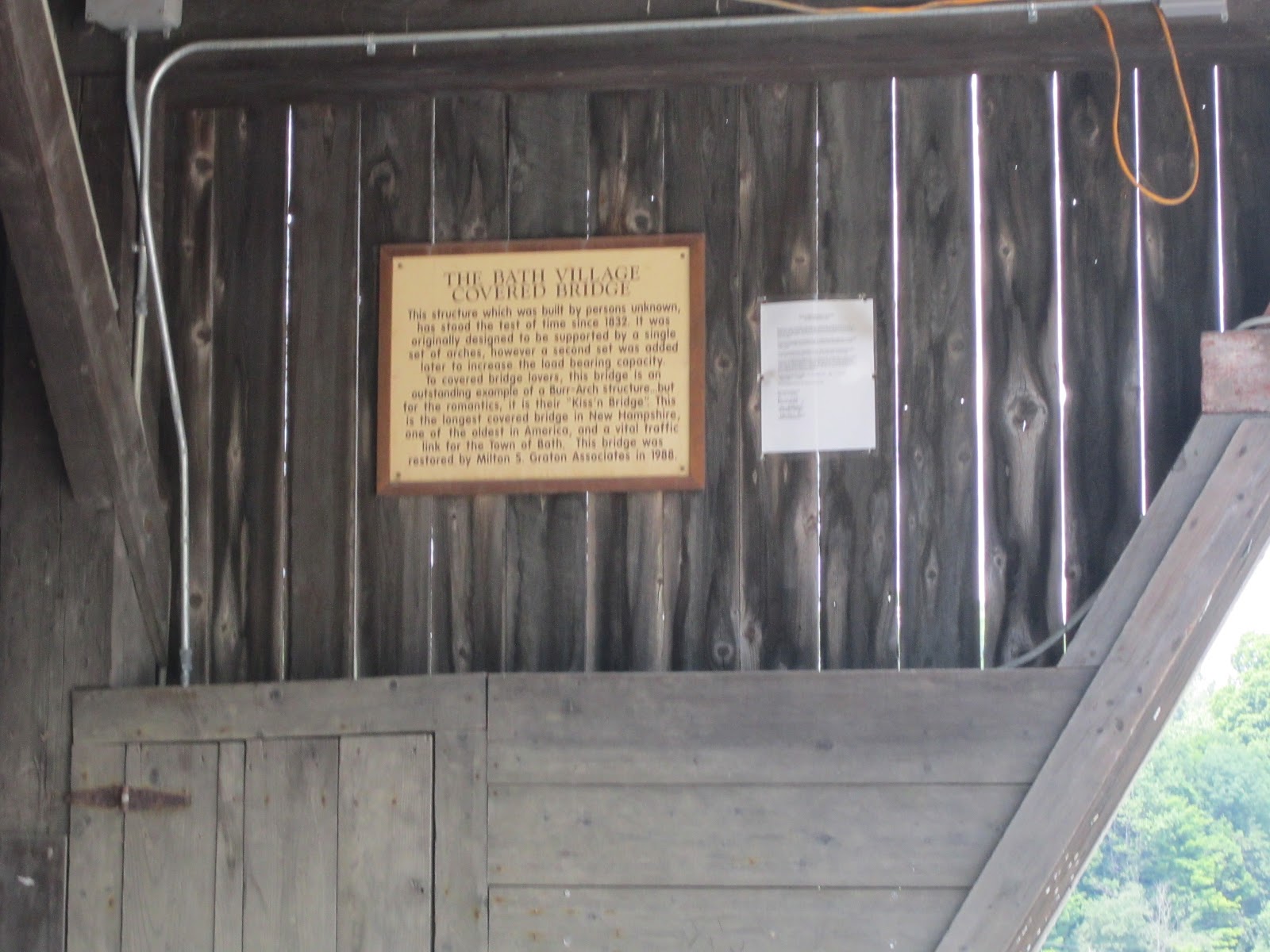
A little reading material about the Bath Village Bridge. This bridge, like several others, claims to be the longest covered bridge in NH.

This is the first bridge that we have visited that has its own stop light to help one vehicle cross at a time.

Natalie was fearful she was going to be stuck on this bridge for 10-15 years...

The view of the Ammonoosuc River.

One final view of the Bath Village Bridge.
As we drove through Woodsville to get to the next bridge, we followed the conclusion of the Woodsville 4th of July Parade. It was such a cute downtown.
The next bridge is one of my favorites...

The Haverhill-Bath Bridge, 1827.

This had to be one of our favorite signs. Really?!? A 200 person limit on the bridge. What would happen if I brought 201 of my closest friends? Has someone tried it?

They are serious about the warning, notice the first camera on a bridge. It is probably to observe how many people are on the bridge at one time.

This is the view from the Haverill-Bath.

Apparently, the people of Haverhill and Bath are big fans of pac-man.

Catcha! Natalie on the Haverill-Bath.
Into Vermont for a bit...

Natalie poses with the Edgell. It was constructed in 1885. (The bridge not Natalie).

This is when I thought it might be a good idea to carry a nature field book with me. Is this home to bats? Moths? Hornets? Water buffalo? If anyone knows, please let me know.

The Clay Brook is some of the murkiest water we have observed under a bridge.

A 3 ton limit is gross!

Kind of like the water. We aren't sure what the pipes are that are emerging from the Clay Brook.

This is also the site of where we decided to enjoy a well deserved picnic lunch.
Next stop, the Packard Hill Covered Bridge.

This bridge had a wonderful area to park and picnic. It also had a conservation area with trails to enjoy nature.

Natalie walking safely on the sidewalk of the Packard Hill Bridge. The bridge was constructed in the 1780s.

This is the second bridge that we have visited with a camera. What happens on these bridges that need to be observed?
At this point in the journey, we were starting to get tired. Driving and bridging takes a lot out of you, especially on a holiday.
Will the bloggers continue on or will they call it a day? Only time will tell...
No comments:
Post a Comment