First thing on Sunday morning, we made a few quick stops for doughnuts, coffee, cheese, chocolate, and pewter. Apparently, Stowe gets us. Then we were off to start our journey of the day.

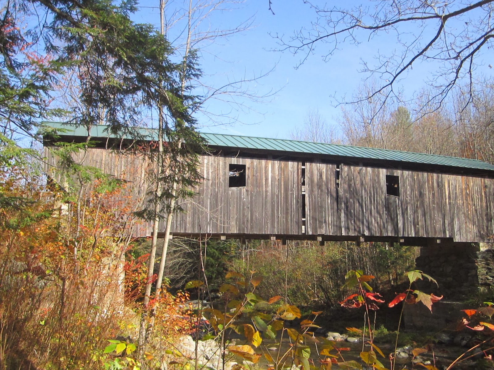
The first bridge of the day was Emily's Day. This cute couple greeted us and asked if we were there to see Emily. We smiled and said yes, but were a little confused.

It turns out Emily, is to believed to have killed herself on the bridge. The couple learned about it on a ghost tour of Stowe.

Makes this picture a little creepier!

Emily's Bridge spans the Gold Brook.

Emily's Bridge is on Covered Bridge Rd. That makes a lot of sense to me.

Natalie poses with the sign.

A view of the Gold Brook.

Emily's Bridge has a Howe Truss.

There is no late night ghost hunting or canoodling at Emily's Bridge.
It was time for another sign trip on our tour.

The Trapp Family Lodge!

The hills are alive...

I wouldn't mind being Trapp-ed here!

The gardens at the Lodge.

I would guess this is where the Trapps grow their grapes.

Natalie soaks in the view.

Picture perfect!

Natalie Von Trapp!

I promise we are almost done here :)

My heart wants to sing every song it hears...

Mum's the word here!
Ok, back on track. Off to the Brookdale Bridge.

The Brookdale Bridge was a hotspot. It was hard to get a shot without others in it.

It spans the West Branch of the Waterbury River.

This fine bridge was built in 1964.

Side view of the Brookdale.

Natalie takes a closer look at the Waterbury River.

The charming Brookdale Bridge.

Just say no to Didymo!
Next stop, the Grist Mill!

We took the most winding and congested roads to get to this charming bridge.
The Grist Mill appears to be a picturesque New England bridge.

Check out this fun bridge!

I love rules with my covered bridges.

The Grist Mill is located in Cambridge, VT.

The Grist Mill has protected reading materials located in it.

A view of the Brewster River.

Slat shot!

I spy the Brewster River.

A sign for the Alden Brewster River Trail.

This charming bridge was built in 1872. While we were visiting a Boy Scout was working on his Eagle Scout project to build a bench. This Boy Scout seemed to appreciate the value of a covered bridge.

Next it was on to the Cambridge Junction Bridge.

Yay! Good signage.

We met a cute couple here from Maine, who was excited that we would take their picture.

Pretty flowers by the Cambridge Junction Bridge.

A view of the Lamoile River.

A view of the river from the bridge.

The sun shines on the Cambridge Junction Bridge.
The next bridge was tough to find. We looked hard for this bridge. Natalie even walked into someone's backyard. Then we looked into a nearby field and saw the Gates Farm Bridge staring back at us.

This is Natalie looking in someone's backyard for the Gates Farm Bridge.

Here is the bridge, which was built in 1897.

The Gates Bridge spans the Seymour River. The Seymour empties into the Lamoile River.
The next bridge was located in the adorable town of Waterville.

Presenting the Church Street Bridge.

This bridge covers the north branch of the Lamoile River.

It is a queenpost truss.

The bridge was built in 1877.

At this bridge we ran into two couples who also share a love of covered bridges.

Next it was on to the Montgomery Street Bridge.

Montgomery Street has its on covered bridge!

This bridge is 70.3 feet long.

It was built in 1887.

Chris was here. We don't know Chris.

A view of the North Branch Lamoille River.

There is a modified queenpost truss.

A picturesque view of the Montgomery Street Bridge.

What a lovely fall day.

Natalie warms herself on the rock during this bridge experience.

At this point, I thought someone was breaking into my car. But then we realized it was our covered bridge loving friends from the last bridge. So we had time for one more shot...

This was totally natural. It looks photoshopped, but it was just that pretty.
Next it was on to the Codding Hollow Bridge.

If you look carefully you can see the woman at the makeshift maple syrup shack who asked us if we wanted to sample her syrup. We appreciated the offer, but pulled a Nancy Reagan and just said no.

A view of the North Branch Lamoille River.

Oh, look. It is our friends from the other bridges. They are from England and call it "bridge spotting." We took their picture for them, but they didn't let me touch their fancy camera...never trust a blogger. We compared routes and discussed what we had already seen. They got us.

Thanks for the fellowship Codding-Hollow!

The Lumber Mill Covered Bridge!

We covered this bridge on our own, which was a rare site on this trip.

Notice the modified queenspost truss.

Another view of the North Branch Lamoille River.
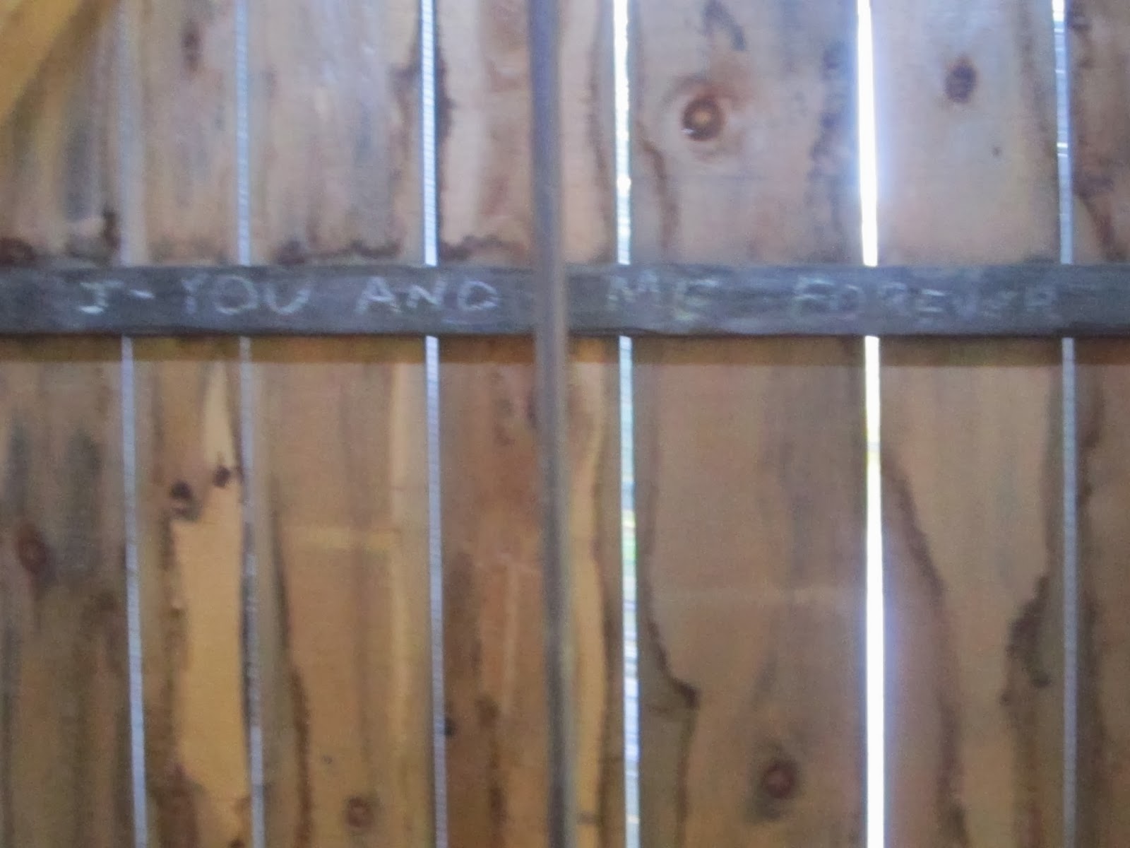
You and me forever...very romantic graffiti. LIES...there is nothing romantic about graffiti, especially covered bridge graffiti.

Well, I guess this makes up for the graffiti, sort of.
Next stop, the Morgan!

The Morgan was built in 1887 by Lewis Robinson.

The sun shines down on this 65.2 feet structure.

This bridge is 11.6 feet tall. That is a little more than 2 Ellens tall.

This little lady bug is bringing us luck!

Natalie is loving life!

And the view!

That's right, its the North Branch of the Lamoille River, again. It's everywhere!

And so are our bridge spotter friends. We ran into them one last time here.

Just for the record, none of us died on the trip. We just parted ways. We were headed to different bridges. I would stand to guess someday our paths will cross on a covered bridge again.

Because....Bridges ROCK!

The Power House, was our next bridge.

It crosses the Gihon River. Strange, I know.

The sun shines on this bridge that was built in 2002 by the Blow and Cote Company.

Here is the Power House from the Power House Bridge. Wonder how they decided on a name...

I love Lucy, I don't think I know Lisa.

This is either a place to wrap your power cord or a platform for flowerboxes.

It sure is a pretty power house. If you look carefully, you can see someone fly fishing. He must have felt pretty famous.

This bridge is 63.6 feet long by 12 feet tall.

This river feeds into the Lamoille River, so if you felt we might be turning our back on the river, we aren't.

Next up, the Scribner.

It was built in 1919.

It has a queenspost truss with I beam stringers.

This friendly little caterpillar welcomed us to the bridge.

The Gihon River!

This bridge is 12.3 feet tall.

This bridge is in a quiet area, but appears to be well travelled, year round.
The journey to the next bridge is a good reminder that sometimes you should not listen to your gps. I place a lot of faith in my gps, but occasionally I need a reminder that I drive a sedan and not an off road vehicle. We went up this hill and pass a meat packing plant and a lumber mill. Then the road disappeared. I don't like to call it quits, but I remember looking at Natalie and saying, "AAA will not be able to get to us out here, if I lose my transmission." So we turned around and the gps got us to the next bridge.

The Red or Sterling Brook Bridge.

It is hard to see, but way down below is the Sterling Brook.

A view of the scenery.

The Sterling Brook eventually flowes into the Waterbury River and then into the Winooski River, and then empties into Lake Champlain.

A very complex truss. It is a combination modified queenpost and modified kingpost.

This is just a show, but it looks like a falcon sitting in the tree.

Bridge decor is important.

That green leaf looks like a dinosaur.

The sign say I love you. It is laminated, but not engraved. This is an acceptable form of bridge romance.

Nice work, Morrisville Rotary Club!
One more bridge stop before we put this journey in the books.

The Fisher Bridge in Wolcott, Vermont!

This bridge was built in 1908.

There was a family taking senior photos here, so we had to wait our turn. Patience is important during bridge hunting.

Here it is the Lamoille River.

Natalie takes her "senior photo."

We love a bridge with lots of warnings.

Hmmm. How safe is this?

This place should be closed after dark.

The train stopped running here in 1995.

It is very impressive.

It is 21 feet tall (more than 4 Ellens) and 103.2 feet long!

I like the style of the top of this bridge. It's like a little hat.

A long view of the Fisher.

One last look at this impressive double town lattice truss.

Good bye, Fisher! It was nice meeting you!
Well, Vemont, you made for one great CDW. We ran into more people loving bridges than I think we have in all of our adventures to date. The weather was wonderful. The sights were breathtaking, Of course, the company was amazing! I think Christopher Columbus would have been proud. If we are being honest, Queen Isabella probably would have preferred to sponsor us over Christopher Columbus. We have a much better success record and I would wager to guess more fun! Thanks again, Vermont!